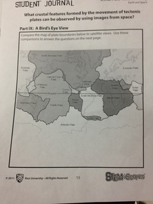
A Bird's Eye View
|
|
1) Which plate boundaries are you able to see using satellite images?
You can see almost all of them because of the convergent boundaries.
2) What crustal features are you able to locate using satellite images?
you can see island arches, volcanoes, mountains, and many more.
3) What effect do you think satellite imagery had on the acceptance of plate tectonic theory?
I think it proves the theory right because you can see the plate boundaries and you can infer on what made those land features be where they are.
